|
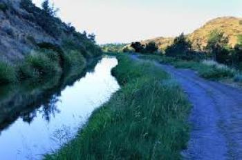
The Link River is a 1.5 mile river which flows through the center of Klamath Falls, draining 3,810 square miles of the northern basin. As a major part of the Pacific Flyway, and as an integral part of the Klamath River drainage, it has a significant impact on fish and fowl, and other flora and fauna.
Its unique power and setting has been recognized and utilized by Native Americans, pioneers, modern engineers and recreationalists. Klamath Falls was named for a series of cascading falls and rapids on the Link River.
Link River DamPacifiCorp operates two hydroelectric plants on the river and allows public access along the road paralleling the river and adjacent to one of the canals supplying water to their West Side hydroelectric plant. This is called the Link River Trail, and is well utilized by numerous individuals and groups. Among these are fishermen, birders, commuters, bicyclers, walkers, runners, black berry pickers, school classes and others. Less developed trails traverse the water’s edge. The eastern ridge of the waterway is Conger Heights, and forms a backdrop of tranquility for those enjoying the trail and river. Irrigation projects in the late 1800s, as well as a dam in the early 1900’s diminished the extent of the falls. Nevertheless, whitewater rapids and a few of the cascades can still be seen today. The falls were often photographed in the late 1800s and early 1900s, and these old photos can be accessed through the Klamath County Museum. Wikipedia
Mill Street
Klamath Falls OR 97601
(541) 594-3000
Website
|

· Klamath Falls, OR Homepage
· Nearby Hotels
· Things To Do in Klamath Falls
· Local Deals
· Getaway Deals
· Map
|